The ocean is the largest wave-making system on Earth, and every rideable surf wave begins as moving air over water. A distant storm can transfer energy into the sea, organize that energy into swell, send it across thousands of kilometers, and finally release it as a breaking wave over a sandbar, reef, or point. Understanding that chain—from wind to swell to surf—makes forecasts easier to read and helps explain why two breaks can look completely different under the same offshore buoy reading. If you want to go deeper on the science behind it all, a book on wave science and ocean giants is a great place to start.
For surfers who want to turn that understanding into better session decisions, a solid surf forecasting guide can bridge the gap between raw forecast data and real-world conditions at your local break. The sections below walk through the full system—from how wind builds waves to how swells transform into surf—so you can read any forecast with more confidence.
The ocean wave-making system starts with wind and storms
Most rideable ocean waves are created by wind. The basic process sounds simple: wind blows over the ocean, the surface becomes rough, and waves grow. In reality, the ocean responds to wind through a set of linked physical processes that determine whether a storm produces weak local chop or powerful long-period groundswell.
How wind first grabs the ocean surface
Wind does not transfer much energy to a perfectly smooth sea. The process usually begins with tiny surface disturbances called capillary waves—small ripples controlled mainly by surface tension. Once they appear, they give the wind a rougher surface to push against.
As wind continues to blow, pressure differences form around the ripples. Air moves faster over some parts of the wave and slower over others, creating patterns of lift and drag. If the wind keeps pushing in the same direction, some ripples grow into gravity waves, where gravity becomes the main restoring force pulling the water surface back down after it is lifted. For surfing, gravity waves are the ones that matter. They can travel long distances, carry significant energy, and eventually break in shallow water.
The three main ingredients: wind speed, duration, and fetch
A storm’s ability to create swell depends mostly on three factors:
- Wind speed: stronger wind pushes more energy into the ocean.
- Wind duration: wind must blow long enough for waves to develop.
- Fetch: the distance of open ocean over which wind blows in the same direction.
Wind speed matters because wave energy increases rapidly as waves get taller. A light breeze may create surface texture, but gale-force wind can build large seas. Duration matters because waves need time to organize. A brief burst of strong wind may create chaotic, short-period waves, while a long-lasting storm can produce a more coherent swell.
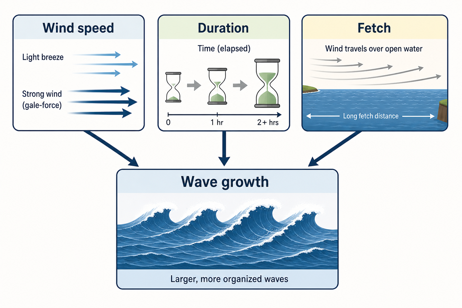
Fetch is especially important for surf. If strong wind blows across a long stretch of open ocean, waves have more room to grow. If the same wind blows over a short distance, land or a shift in wind direction cuts off the energy supply before a powerful swell can form. If you’re serious about tracking local wind conditions, a handheld anemometer lets you measure wind speed and direction at the beach, which can help you make sense of how local conditions compare to what the forecast predicted.
Why storms are the ocean’s best wave engines
Large low-pressure systems are effective wave makers because they combine strong wind, long duration, and broad fetch. The best surf-producing storms often have a wide area of wind aimed toward the coast, and they move in a way that keeps feeding energy into the same wave field.
Storm movement matters. If a storm tracks in the same direction as the waves it is generating, it can keep adding energy to them over a longer period. This is sometimes called a captured fetch. In those cases, the storm and the developing swell travel together, helping create larger and longer-period waves than a stationary or poorly aligned storm would produce.
Not every intense storm makes good surf for every coastline, though. The wind must be aimed along a clear ocean path toward the surf spot. Islands, continents, and underwater ridges can all block or reduce swell energy before it arrives. Keeping an eye on barometric pressure trends is one way to monitor approaching storm systems—a marine barometer makes it easy to track pressure changes at home or on the water.
How wind transfers energy into waves for surfing
Wind transfers energy to the ocean through friction, pressure, and timing. The most efficient transfer happens when wind blows faster than the waves are moving and continues pushing on the back of the waves as they travel.
From messy wind sea to organized swell
Close to the storm, the ocean surface is usually chaotic. Waves of different sizes, periods, and directions overlap to create what’s called a wind sea. It can be rough and powerful, but it’s often disorganized and inconsistent.
As waves move away from the storm, they begin to sort themselves out. Longer-period waves travel faster than shorter-period waves in deep water, so the longest-period waves outrun the rest and arrive first at distant coastlines. The result is swell: a more organized train of waves that can travel far beyond the wind that created it. This sorting process is called dispersion, and it’s one reason a new groundswell often begins with long waits between sets before filling in as more wave energy arrives.
Fully developed seas and wave growth limits
A sea becomes fully developed when wind has blown long enough over enough fetch that waves can no longer grow significantly under the existing wind speed. At that point, additional time won’t increase wave height unless wind speed or fetch also increases.
In the real ocean, many storms are not perfectly steady. Winds shift, fetch areas change, and storm systems interact with each other. That’s why swell fields often contain several wave groups rather than one clean, uniform train. For surfers, this means the best swells usually come from storms that are not only strong, but also well-positioned and well-organized. A smaller, focused storm aimed directly at a coastline can sometimes create better surf than a massive storm whose strongest winds point the wrong way.
Ocean waves move energy through water, not water across the ocean
One of the most important ideas in wave physics is that waves transport energy—not large masses of water—across the ocean. A swell can travel thousands of kilometers, but the individual water particles mostly move in loops rather than traveling along with the wave from storm to shore.
Orbital motion beneath ocean waves
In deep water, water particles under a passing wave move in nearly circular orbits. Near the surface, the orbits are largest. With depth, the motion decreases quickly. At a depth of roughly half the wavelength, very little wave motion remains.
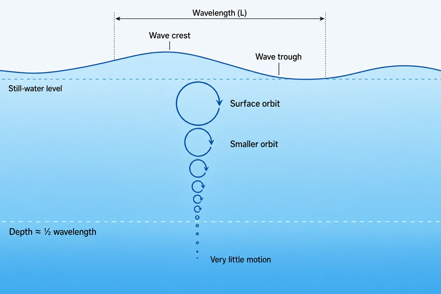
This is why long-period swell can “feel” the bottom in deeper water than short-period swell. Long-period waves have longer wavelengths, so their orbital motion reaches farther down. A 16-second swell interacts with the seabed much farther offshore than an 8-second swell. In shallow water, the circular motion becomes more elliptical as the seabed restricts the lower part of the orbit—a key part of how swell transforms into breaking surf.
Wave speed, wavelength, and period
Wave period is the time between wave crests passing a fixed point. In deep water, period determines both speed and wavelength. Longer-period waves travel faster and have longer wavelengths. A useful deep-water approximation is:
Wavelength in meters ≈ 1.56 × period²
Using that estimate:
- A 10-second swell has a wavelength of about 156 meters.
- A 15-second swell has a wavelength of about 351 meters.
- A 20-second swell has a wavelength of about 624 meters.
Long-period swell is powerful partly because its energy is spread through a much deeper and longer section of the water column. When that energy compresses over shallow bathymetry, the wave can grow dramatically.
Group speed and why waves arrive in sets
Individual wave crests move at one speed, but wave energy travels at a different speed called group speed. In deep water, group speed is roughly half the speed of the individual crests. This matters because swell energy travels in packets, which surfers experience as sets.
Sets form because wave components with slightly different periods and directions overlap. When they line up, they produce a group of larger waves. When they don’t, the surf goes quiet for several minutes. This is why a forecast can show a solid swell while the beach still has lulls—the energy is there, but it arrives in groups rather than as a perfectly even sequence of waves.
Wave height, period, and direction are the core surf forecast measurements
Surf forecasts reduce a complex ocean into a few key measurements. The most important are wave height, period, and direction. Each tells only part of the story, but together they describe the swell’s size, energy, and path.
Wave height: buoy height versus breaking wave face
Wave height is the vertical distance from trough to crest. Offshore buoys typically report significant wave height, which is the average height of the highest one-third of waves measured during a sampling period. This is not the same as the height of every wave, and it is not the same as surf face height at the beach.
Individual waves can be much larger than the reported significant wave height. In a typical sea state, some waves may be 1.5 to 2 times the significant height. That’s one reason a buoy reading can look modest while occasional sets arrive noticeably bigger than expected.
Surf height also depends on local transformation. A 2-meter, 16-second swell may create much larger breaking waves at a focused reef than at a sheltered beach. A 2-meter, 8-second swell may look weaker at the same spot because it carries less deep-water energy and interacts differently with the bottom.
Wave period: the key to swell energy
Period is one of the best clues to a swell’s power. Short-period waves are usually produced by nearby winds and tend to be weaker, steeper, and less organized. Long-period waves are often generated by distant storms and can carry energy across entire ocean basins. As a general surfing guide:
- 5 to 8 seconds: local wind swell or short-period regional swell.
- 9 to 12 seconds: medium-period swell with moderate organization.
- 13 seconds and above: groundswell with stronger shoaling potential.
This is only a guide. A 10-second swell can be excellent at the right beachbreak, while a 20-second swell can close out exposed spots or miss breaks that need a different angle. Period must always be read alongside height, direction, and local bathymetry.
Wave direction: where the swell comes from
Swell direction describes where the waves are coming from, not where they are going. A 270-degree swell comes from the west and travels east. This convention matters when matching a forecast to a specific coastline.
Every surf spot has a swell window—the range of directions from which swell can reach it. A beach exposed to the southwest may be flat during a large northwest swell if a headland blocks the energy. A reef facing southeast may come alive from a small but well-aimed swell that passes directly into its window. Direction also affects how a wave breaks. Swell arriving straight into a beach often creates closeouts, while swell arriving at an angle can produce a peeling wave because one section of the crest reaches shallow water before the next.
A good coastal navigation training chart can help you visualize coastline orientation and start identifying which swell directions are likely to reach your local breaks. Pairing that with a standard nautical chart reference guide gives you the tools to read depth contours, understand headland geometry, and see why certain breaks behave the way they do.
Wave shape, power, and consistency determine surf quality
Height, period, and direction describe the incoming swell, but surfers also care about how the wave actually breaks. Wave shape, power, and consistency depend on both the swell and the surf spot.
Wave shape: why some waves peel and others close out
Wave shape is influenced by swell steepness, seafloor contour, and local wind. A wave becomes steeper when its height is large relative to its wavelength. If it gets too steep, it breaks. The seabed controls where different parts of the wave slow down first. When a swell approaches a gradual sandbar, it may spill gently. When it hits a steep reef or ledge, the wave may pitch quickly and form a hollow barrel. Points often create long peeling waves because the swell wraps along a curved coastline or underwater contour.
Common breaking styles include:
- Spilling waves: softer waves that crumble progressively down the face.
- Plunging waves: steeper waves that throw the lip outward and often tube.
- Surging waves: waves that rush up a steep slope with limited or no breaking.
Local wind can improve or damage wave shape. Offshore wind holds up the face and delays breaking. Onshore wind adds bump and makes the lip crumble earlier. Light wind or clean offshore flow allows the swell and bathymetry to shape the wave more clearly. A wireless weather station at home can help you track wind direction, temperature, and barometric trends so you’re not caught off guard when conditions change.
Wave power: why period matters as much as size
Wave power increases with both height and period. In deep water, wave power per meter of crest is roughly proportional to wave height squared multiplied by wave period. This means a small increase in height can make a large difference—doubling wave height roughly quadruples the energy. A longer period adds even more power because the wave has a longer wavelength and deeper orbital motion.
This is why two swells with the same height can feel completely different in the water. A 1.5-meter swell at 7 seconds may produce weak, crumbly surf. A 1.5-meter swell at 16 seconds can produce strong, powerful sets at the right break.
Wave consistency: why some swells have long lulls
Consistency describes how often rideable waves arrive. It is affected by the size of the swell source, the spread of wave periods, and how energy is distributed across the swell field. A broad, nearby storm may produce consistent surf because many wave groups are arriving from a wide area. A distant, long-period groundswell may deliver excellent waves but with longer lulls, because the energy is more sorted and arrives in narrower bands.
Consistency also depends on exposure. A break near the edge of a swell window may only receive part of the energy, so sets can be infrequent. A fully exposed beach may see more waves, but not necessarily better ones if the swell is too straight or too mixed.
How open-ocean swell becomes rideable surf at a surf spot
The journey from open-ocean swell to breaking surf is a transformation. In deep water, swell may look like smooth rolling lines. As it enters shallower water, it slows, bends, steepens, and eventually breaks.
Shoaling: how swell grows in shallow water
Shoaling begins when a wave starts to feel the seabed—typically when water depth is less than about half the wavelength. As the lower part of the wave interacts with the bottom, the wave slows down. Since the period stays nearly the same, the wavelength shortens. As the wave compresses, its height often increases. The energy is being squeezed into a shorter horizontal distance and shallower water column, which is why a swell that looks low and gentle offshore can rise quickly as it approaches a reef or sandbar.
Eventually, the wave becomes too steep to support itself and breaks. A widely used rule of thumb is that many waves break when wave height reaches about 78 percent of the water depth, though actual breaking depends on slope, wave shape, and seabed contour.
Refraction: how swell bends toward shallow water
Refraction is the bending of waves as different parts of the wave crest travel at different speeds. The part of the wave in shallower water slows first, while the part in deeper water continues faster. This gradually turns the crest. Refraction can focus or spread swell energy—around underwater canyons, reefs, and points, it can bend waves into a concentrated zone and make the surf much larger than at nearby beaches. In other places, refraction spreads energy out and reduces wave height.
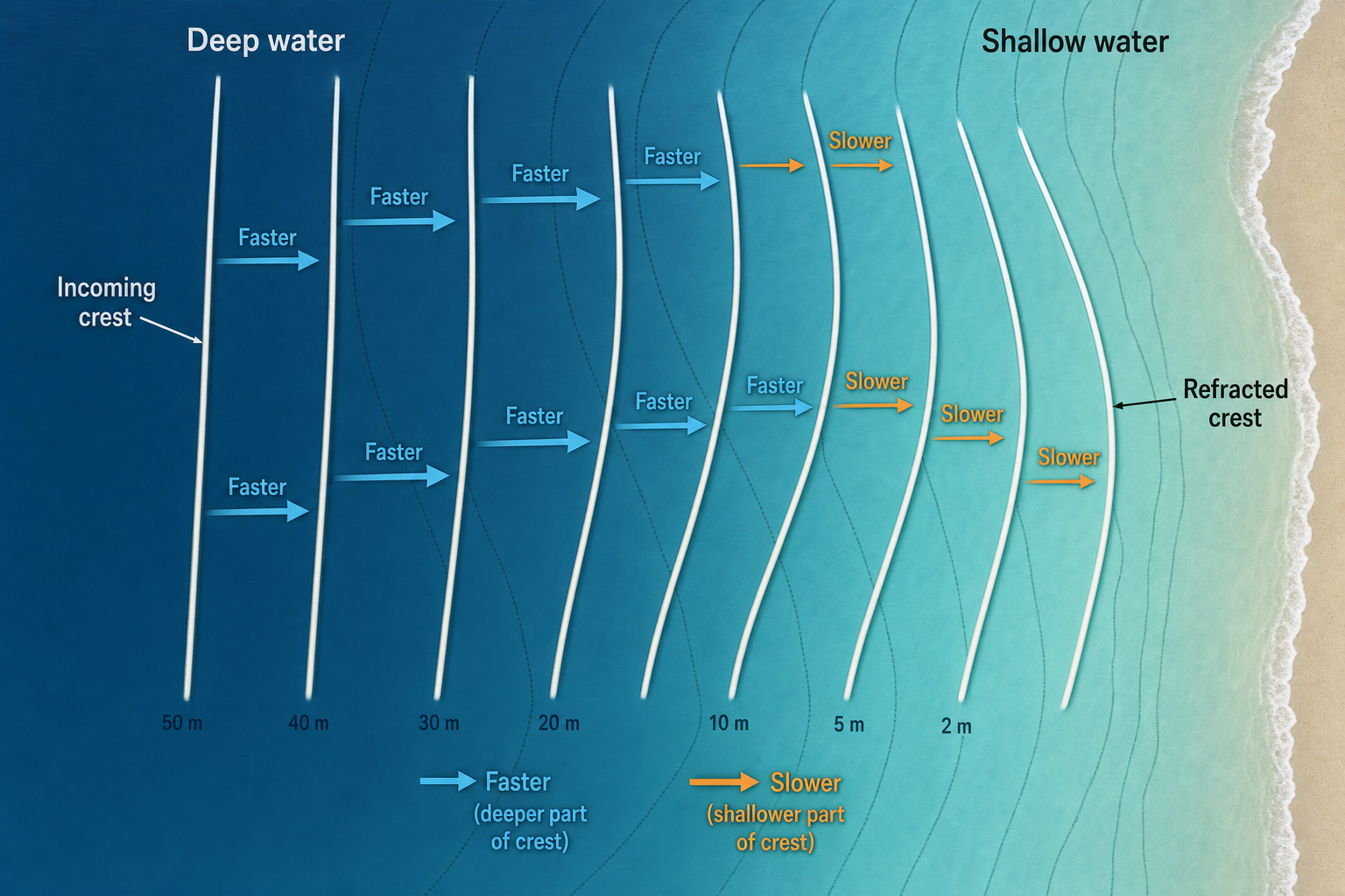
This explains why surf reports from neighboring spots can be very different. One break may focus a swell direction perfectly while another a short distance down the coast sits in a shadow or receives a less favorable angle. A waterproof orienteering compass is handy for confirming which direction a break actually faces, so you can match it accurately to the swell direction in the forecast.
Diffraction, shadowing, and swell windows
Swell doesn’t always travel in perfectly straight lines, but obstacles still matter. Islands, headlands, and reefs can block energy and create swell shadows. Some wave energy can bend around obstacles through diffraction, but the shadowed area usually receives smaller and less consistent surf. Longer-period swells often wrap better than short-period swells, but they are also more sensitive to deep-water bathymetry because they interact with the bottom earlier. This can make long-period swells surprisingly selective—one spot may be firing while another nearby spot is flat.
Tide and water depth at the surf spot
Tide changes the depth over the breaking area, which can alter wave height, steepness, speed, and how sections connect. Some reefs need enough water to break cleanly. Some sandbars perform best at lower tide because the shallower bottom helps the wave stand up. A wave that peels at mid tide may become too fat at high tide or too fast at low tide. The same swell can produce several different versions of the same break over a single tidal cycle. A tide clock mounted at home makes it easy to track the tidal cycle at a glance without having to pull up an app every time.
How to read a surf forecast using ocean wave physics
A surf forecast is most useful when you treat it as a description of moving energy, not a simple promise of wave height. The goal is to identify the swell components, decide which ones matter for your spot, and account for local transformation.
Separate swell components instead of reading only the headline size
Many forecasts display a combined wave height, but the ocean may contain several swells at once. A buoy could be measuring a short-period local wind swell and a longer-period groundswell at the same time. The combined number may not tell you which swell will actually create the best surf at your break. Look for the individual swell height, period, and direction. A smaller long-period swell from the ideal direction may matter more than a larger short-period swell from a poor angle.
Match swell direction and period to the surf spot
Each break has its own preferences. Some beachbreaks perform well on medium-period swell because it creates workable peaks rather than long closeout lines. Some reefs need long-period swell to bend and focus correctly. Some points require a precise swell angle to peel instead of sectioning. Experience is often the missing layer in any forecast. Over time, surfers learn that a certain spot works best on a southwest swell at 14 seconds, while another nearby break prefers west swell at 10 seconds. The physics explains the pattern, but local observation confirms it. Keeping a surf log or journal is one of the best ways to build that knowledge—track the swell, the conditions, and how your local breaks responded, and patterns will emerge over time.
If you prefer something more field-ready, a weatherproof pocket notebook holds up to moisture, sand, and saltwater so your notes survive the session.
Translate offshore swell into breaking wave size carefully
There is no universal conversion from buoy height to surf height. Breaking wave size depends on bathymetry, swell direction, and period. A long-period swell may double or triple in face height at a focusing reef, while a short-period swell may barely grow before breaking. Forecast models estimate this transformation, but small bathymetric details can change everything. Sandbars shift, reefs have complex contours, and submarine canyons can focus swell into narrow zones. That’s why local knowledge remains valuable even with advanced forecast tools. A pair of compact waterproof binoculars is useful for checking a spot from the cliff or the car park before you paddle out—you can read the wave shape, count the sets, and see how the swell is breaking without committing to the water.
Account for local wind and surface quality
Even a well-aimed swell can be ruined by poor local wind. Strong onshore wind adds chop and disrupts the wave face. Cross-shore wind can create an uneven, textured surface. Offshore wind can groom conditions, though very strong offshore flow may make waves harder to paddle into or hold them up too long before breaking. Because swell and local wind are separate parts of the forecast, they should be read separately. The swell tells you whether there is energy in the water. The wind tells you how cleanly that energy may break. If you want to shoot video of your sessions while reading conditions, an action camera mounted on your board or helmet captures the session in detail, which can be useful for reviewing how different swells actually broke at your spot. Keeping your phone dry while you’re checking the forecast or filming from the beach is easier with a waterproof phone pouch.
Why the same swell creates different waves at different breaks
A single swell can produce hollow barrels at one spot, soft shoulders at another, and closeouts somewhere else. The difference comes from how each coastline transforms the incoming energy.
Beachbreaks, reefs, and points shape swell differently
Beachbreaks depend heavily on sandbar shape and can change quickly after storms or strong currents. A well-formed sandbar creates a peak or angled section that lets the wave peel. A straight bar often makes the wave break all at once. Reefs are more fixed, and because their bathymetry changes less, they tend to be more predictable. A reef may have a narrow swell window and a preferred tide, but when the right swell arrives, it can transform energy very efficiently. Points guide waves along a curve or angled bottom, often turning incoming swell into long, peeling rides. Their quality depends on how the incoming wave angle matches the shape of the point and the underwater contours around it.
Underwater canyons and offshore banks can magnify swell
Deep-water canyons near shore can strongly affect surf quality. Because long-period waves interact with bottom contours in deeper water, canyons can bend swell around them and concentrate energy toward specific beaches or reefs. Offshore banks can also cause waves to shoal, refract, or even break before the main coastline. This is why some famous surf zones are unusually consistent or powerful—they’re not just exposed to swell, they’re positioned near bathymetry that organizes and concentrates wave energy in ways that nearby spots don’t benefit from. A handheld GPS navigator can help you mark specific locations along a coastline and start connecting what you see in the water with what the charts show below the surface.
The ocean creates rideable waves through a continuous chain of energy transfer and transformation. Wind and storms generate waves in the open ocean, longer-period waves sort themselves into swell and travel far beyond the storm, and that swell eventually reaches shallow water where bathymetry bends, slows, and steepens it until it breaks. For surfers, understanding wave height, period, direction, shape, and power turns a forecast from a set of numbers into a readable story about how energy will arrive at the coast. The more clearly you understand that story, the better you can predict where and when the ocean will turn distant wind into a wave worth riding.