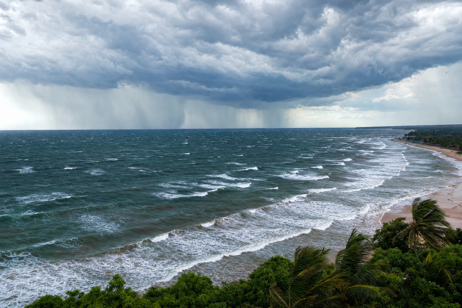
The Bay of Bengal is one of the most dynamic swell-generating basins in the world, but it doesn’t behave like an open ocean. Its waves are shaped by monsoons, tropical cyclones, short fetches, and the complicated coastlines of India, Bangladesh, Myanmar, and Sri Lanka. For surfers, this means the Bay can be quiet and wind-chopped for long stretches, then suddenly deliver strong, directional swell when the right storm lines up. Understanding how Bay of Bengal waves are generated is the key to knowing which storms will matter, when the swell will arrive, and whether the surf will actually be clean enough to ride. If you want to go deeper on the science behind it all, this surf forecasting guide does an excellent job of connecting meteorology to real-world wave reading.
How Bay of Bengal Waves Are Generated
All surfable waves begin with wind transferring energy into the sea surface. The size and quality of those waves depend mainly on three factors: wind speed, fetch, and duration. Getting familiar with these concepts will sharpen your ability to read any forecast. A solid reference like an introductory oceanography text can help fill in the gaps if the science side of forecasting is new to you.
Wind Speed, Fetch, and Duration in Bay of Bengal Swell
Wind speed is the first requirement. Light winds may create surface texture, but surfable swell generally needs sustained winds of at least 15 to 20 knots. Strong monsoon winds, deep depressions, and cyclones can exceed that threshold easily.
Fetch is the distance over open water that the wind blows in one consistent direction. The Bay of Bengal is semi-enclosed, so fetch is limited compared with the Southern Ocean or the Pacific. A strong wind field blowing across 500 to 1,000 kilometers of open water can generate useful surf, but the resulting wave periods are usually shorter than what you’d see from open-ocean groundswell.
Duration is how long the wind blows over the same area. A brief squall may kick up a short burst of choppy waves. A monsoon surge lasting several days can build steady, consistent surf. A slow-moving cyclone tends to produce the most powerful Bay of Bengal swell because intense winds remain over open water long enough for the sea state to fully develop.
Why Bay of Bengal Swell Is Often Short to Medium Period
Because the Bay is bounded by land on three sides, locally generated waves commonly have periods of 6 to 10 seconds. Strong depressions can push periods to 10 or 11 seconds, while well-organized cyclones can produce swell in the 12 to 15 second range. Very long-period energy above 16 seconds is uncommon when waves are generated inside the Bay itself.
There is one important exception: remote Southern Indian Ocean swell. Long-period south or southeast energy from distant Southern Ocean storms can occasionally reach Sri Lanka, the southern Bay entrance, and exposed parts of the Andaman and Nicobar Islands. For much of India’s east coast, however, the shape of the Bay and the presence of Sri Lanka tend to block or weaken this energy significantly.
Storm Types That Generate Surfable Bay of Bengal Waves
Monsoon Wind Fields
Monsoon winds are the most reliable source of seasonal Bay of Bengal waves. They aren’t always storms in the compact cyclone sense. Instead, they are broad pressure-gradient wind fields that can blow for days or even weeks at a time.
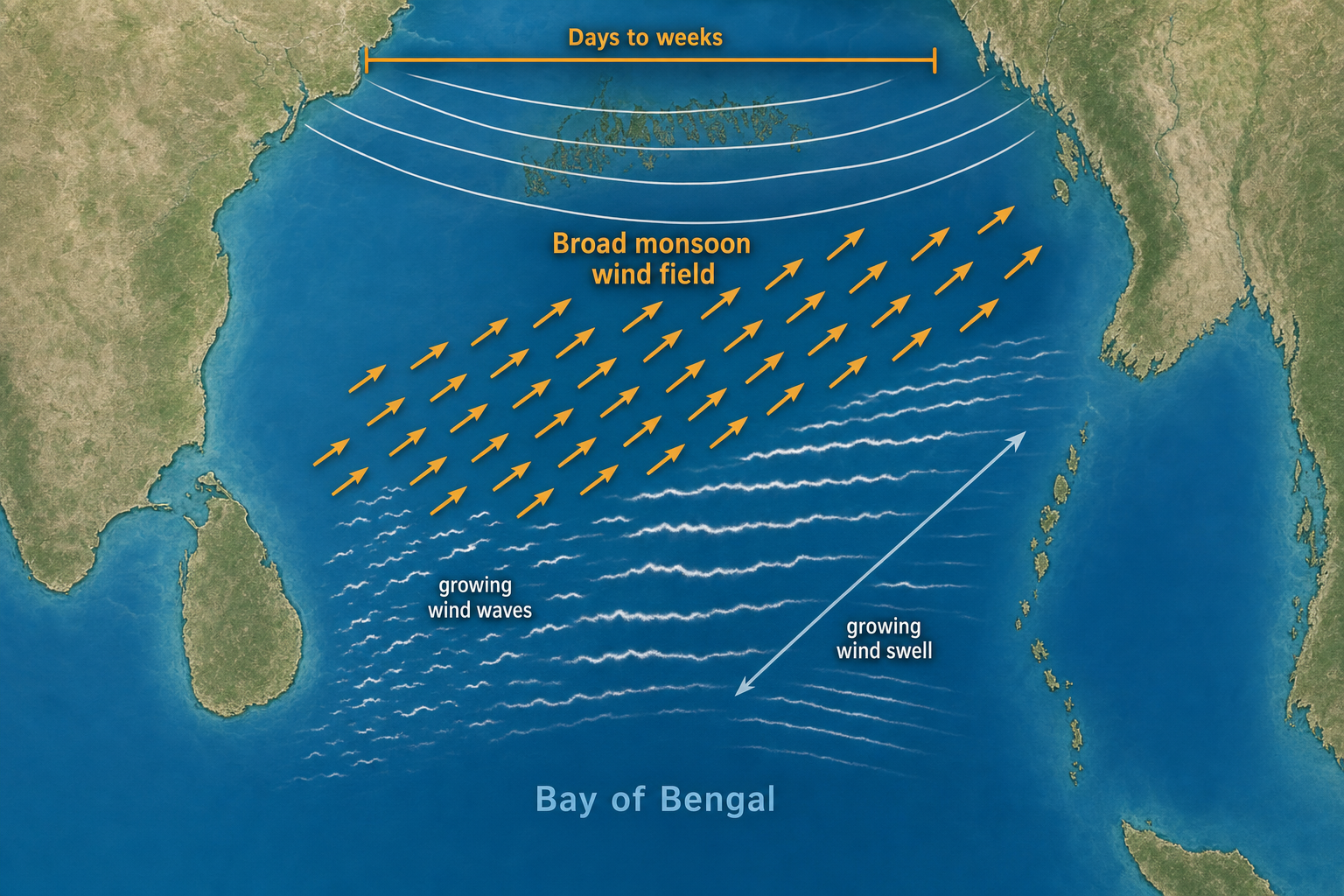
During the southwest monsoon, roughly June through September, winds commonly blow from the southwest or south across the Bay. These winds create south, southeast, and locally south-southwest swell depending on coastline orientation. The surf is typically short to medium period, but it can be impressively consistent when the monsoon is running strong.
During the northeast monsoon, mainly October through February, winds blow from the northeast across the Bay toward the equator. This produces northeast and east-northeast wind swell, especially for east-facing coasts. It can be surfable, but quality often suffers because the same winds that create the waves may also blow directly onshore at exposed beaches.
Monsoon Depressions and Deep Depressions
Monsoon depressions are broad low-pressure systems embedded in the seasonal monsoon trough. They are weaker than tropical cyclones but often larger, slower-moving, and far more common. The India Meteorological Department classifies systems by wind speed, with depressions generally producing winds around 17 to 27 knots and deep depressions around 28 to 33 knots.
These systems can generate useful surf when their strongest winds aim at an exposed coast for at least a day. Typical surf from a depression runs in the 3 to 8 foot range on exposed coasts, with periods around 7 to 11 seconds. Quality depends heavily on local wind. A depression sitting too close to the coast often produces stormy, uneven surf that’s difficult to read.
Tropical Cyclones in the Bay of Bengal
Tropical cyclones are the strongest swell generators in the Bay. The basin is well known for producing intense cyclones because sea surface temperatures are frequently very warm, especially just before and after the southwest monsoon. Cyclone classification begins at around 34 knots of sustained wind, with severe and very severe cyclonic storms producing substantially more powerful wind fields.
A cyclone can generate large, powerful waves if it has a broad gale field rather than a tiny core, a track that keeps the fetch aimed toward the surf zone, and enough distance from land for the swell to organize. The best cyclone swell is not always produced by the strongest storm. A compact cyclone moving quickly into land may deliver less rideable surf than a weaker but broader system tracking slowly across the central Bay. In forecasting, the size and alignment of the wind field matter just as much as the central pressure reading.
Thunderstorm Squalls and Nor’westers
Pre-monsoon thunderstorms, including the “Nor’wester” squalls common to eastern India and Bangladesh, can create sudden short-period waves. These events are usually too localized to generate quality surf on their own. They tend to produce 4 to 7 second wind chop and rapidly changing conditions rather than anything organized.
Squalls become more relevant when they arrive on top of an existing swell. A morning with clean cyclone swell can deteriorate quickly if local thunderstorm outflow shifts the wind onshore.
Remote Southern Indian Ocean Swell
Although not Bay-generated, remote Southern Indian Ocean swell is important for Sri Lanka and the southern Bay entrance. Strong low-pressure systems far south of the equator can send long-period south or southeast swell toward Sri Lanka’s east and southeast coasts, often running 12 to 18 seconds. These swells frequently appear cleaner and more organized than local Bay wind swell.
For most Bay of Bengal forecasting, it’s worth separating locally generated Bay swell from remote southern swell. They have different periods, different arrival times, and different ideal local wind conditions.
Seasonal Patterns for Bay of Bengal Waves
The Bay of Bengal follows a strong seasonal rhythm driven by the monsoon cycle. The details vary by coast, but the following patterns are a practical starting point for forecasting across the region. Wave heights below refer to typical surf face size at exposed breaks, not maximum offshore storm seas.
| Season | Main Weather Pattern | Typical Swell Direction | Typical Size and Period | Wave Quality |
|---|---|---|---|---|
| January to February | Weakening northeast monsoon, cooler continental air, fewer major storms | NE to E in the northern and western Bay; SE or S energy near Sri Lanka when remote swell is present | 1 to 4 ft, 5 to 8 seconds; occasional longer-period southern swell | Often small. Clean windows occur with light morning winds or on sheltered coastlines. |
| March to May | Hot pre-monsoon season, very warm sea surface, increasing instability, elevated cyclone risk | E, SE, or S depending on cyclone position; short-period local wind waves between storms | 2 to 5 ft normally; 4 to 12 ft or more from cyclones, 8 to 15 seconds | Highly variable. Cyclone swells can be powerful, but local winds and storm proximity determine quality. |
| June to September | Southwest monsoon, broad S to SW winds, monsoon lows and depressions | S to SE for much of India’s east coast; SE to S around Sri Lanka; S to SW for parts of Bangladesh and Myanmar | 2 to 6 ft common, 6 to 10 seconds; bigger during depressions | Consistent but often wind-affected. Points, reefs, and morning land breezes can improve conditions considerably. |
| October to December | Northeast monsoon and peak post-monsoon cyclone season | NE to E from monsoon surges; E, SE, or S from cyclones depending on storm track | 3 to 8 ft common during active spells; cyclone swell can exceed 10 ft, 9 to 15 seconds | Potentially the strongest season. Exposed beaches may be messy under northeast winds, while sheltered setups can be excellent after a wind shift. |
Typical Bay of Bengal Swell by Storm Type
Southwest Monsoon Swell
Southwest monsoon swell is generated by broad S to SW wind flow across the Bay and is most consistent from June through September. Periods are commonly 7 to 10 seconds, with exposed surf in the 2 to 6 foot range. Stronger monsoon bursts or embedded depressions can push things larger.
Quality depends heavily on coastline orientation. On parts of India’s east coast, southwest winds may actually be offshore or sideshore near land, even while the Bay itself has enough southerly wind to create waves. On Sri Lanka’s east coast, the southwest monsoon can be favorable because local winds may blow offshore while southeast swell reaches the points.
Northeast Monsoon Swell
Northeast monsoon swell is generally shorter period and more wind-affected than its southwest counterpart. It runs from October through February, with the most active period typically October to December. Exposed beaches may see 2 to 6 foot surf at 5 to 9 seconds during strong surges.
The main challenge is local wind. Since northeast winds often blow directly onto east-facing coasts, the same weather pattern that makes waves can also make them choppy and difficult to surf. Better quality usually shows up in protected corners, on coasts with a favorable angle, or when the wind backs off after the swell has already built.
Depression and Deep Depression Swell
Depressions create more organized surf than ordinary monsoon flow because winds curve around a defined low-pressure center. A deep depression over the central Bay can produce a wide area of 25 to 35 knot winds. When that fetch points toward an exposed coast, surf can build into the 3 to 8 foot range with 8 to 11 second periods.
Depression swell is often less clean than cyclone swell because the system may be broad, rainy, and uncomfortably close to shore. However, it can be very worthwhile when local winds are light or offshore. These systems are especially relevant during the southwest monsoon, when fully developed cyclones are less frequent.
Tropical Cyclone Swell
Cyclones can produce the largest and most powerful Bay of Bengal waves. Near the storm, offshore wave heights can become extreme, but what reaches the coast depends on distance, direction, and coastal exposure. A well-placed cyclone can send 6 to 12 foot surf to exposed breaks with periods commonly in the 10 to 15 second range.
Cyclone swell is usually more directional than monsoon swell. A storm in the eastern or central Bay may send E or SE swell toward India’s east coast. A system north or northeast of Sri Lanka can push E or NE swell toward the island’s east coast. For Bangladesh and Myanmar, storms in the central and southern Bay often produce S or SW swell components.
The key forecasting principle is straightforward: don’t forecast from the storm center alone. Find the strongest wind field and ask whether those winds are blowing across open water toward your surf spot.
Weather Factors That Create Bay of Bengal Surf
Sea Surface Temperature and Cyclone Fuel
The Bay of Bengal runs warm, with sea surface temperatures around 28 to 31°C during the main cyclone seasons. Tropical cyclones generally need water above about 26.5°C to form and sustain themselves, but warm water alone isn’t enough. The atmosphere also needs moisture, low vertical wind shear, and a pre-existing disturbance to get things going.
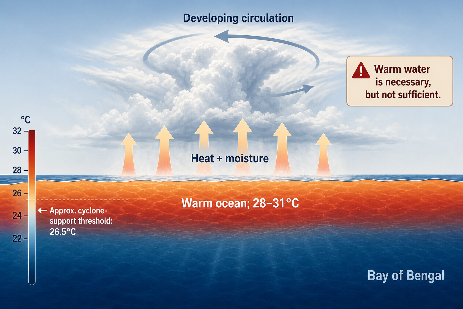
The Bay’s warm upper ocean helps storms intensify quickly, especially in April, May, October, and November. Freshwater from rivers and heavy rainfall can create a buoyant surface layer that traps heat near the ocean’s top. That layering can support rapid intensification when atmospheric conditions are right.
Atmospheric Pressure and Wind Gradient
Waves aren’t generated directly by low pressure. They’re generated by wind, and wind is driven by pressure differences. A tight pressure gradient means stronger winds. On a weather map, closely spaced isobars around a low-pressure center usually indicate stronger wind and better swell potential. Tools like a marine barometer can help you track local pressure trends when you’re near the coast, giving you an early heads-up on changing conditions.
Central pressure matters, but it can be misleading. A cyclone with a central pressure near 960 hPa may generate massive seas if it has a broad wind field. A smaller storm at similar pressure may produce far less surf if its gale-force winds are confined tightly around the eye.
Monsoon Troughs and Regional Wind Flow
The monsoon trough is a zone of low pressure and converging winds. When it lies across the Bay, disturbances can form along it and develop into depressions. These systems often move westward or northwestward toward India, Bangladesh, or Myanmar.
During the southwest monsoon, the pressure gradient between the southern Indian Ocean high and the heated Asian landmass drives strong seasonal flow across the Bay. During the northeast monsoon, higher pressure over the Asian continent pushes cooler, drier air southward. That creates northeast wind surges and can also spin up post-monsoon lows over the still-warm Bay water.
What Bay of Bengal Storms Look Like on a Weather Map
Monsoon Wind Events on Forecast Maps
A monsoon wind event looks like a broad area of 15 to 30 knot winds rather than a tight circular storm. On surface pressure charts, you’ll see elongated isobars and a large-scale pressure gradient. On wind maps, look for long bands of arrows or wind barbs pointing consistently across the Bay.
For surf forecasting purposes, alignment is the key detail. If wind arrows point along an open-water path toward your coast, the event has swell potential. If the fetch points away, waves may build elsewhere while your spot stays small. A good weather terminology reference is genuinely useful here for decoding the charts and model outputs you’ll encounter. You might also consider keeping a weatherproof notebook handy for jotting down observations when you’re out near the water.
Depressions on Weather Maps
A depression typically appears as a closed or partly closed low-pressure circulation with a broad area of rain and curved wind flow. The isobars are not as tightly packed as a cyclone, and satellite imagery often shows disorganized convection rather than a clean spiral band structure.
On wave models, depression swell appears as a widening area of moderate seas. Periods often rise into the 8 to 11 second range if the system persists. The swell may not separate cleanly from local wind sea when the low is sitting close to the coast.
Tropical Cyclones on Weather Maps
A tropical cyclone appears on a pressure chart as a compact low with closed isobars, strong wind barbs, and organized spiral rainbands. Stronger cyclones may show a central dense cloud shield or a visible eye on satellite imagery. Storms like Fani, Amphan, and Mocha illustrated how rapidly Bay systems can intensify when sea temperatures, moisture, and wind shear all align at once.
On a swell forecast, a cyclone typically creates a concentrated zone of very large seas near the storm, with longer-period swell radiating outward ahead of it. The first energy to arrive at a distant coast is usually the longer-period component. Shorter-period energy follows later and may blend with local wind sea as the system approaches or makes landfall.
How to Forecast Bay of Bengal Waves from Storms
Step 1: Know the Surf Spot’s Swell Window
Before analyzing any storm, define what directions your break can actually receive. A beach open to the east may pick up E and SE swell but miss S swell if it’s blocked by land. A Sri Lankan point may perform well on SE swell but become messy under direct NE wind swell. A reef in the Andamans may be highly sensitive to even small direction changes.
Bathymetry matters too. Submarine canyons, shoals, and continental shelves can focus or weaken swell energy. The shallow northern Bay transforms waves very differently from the deeper waters near Sri Lanka and the Andaman Sea. A coastal navigation chart can help you understand the seafloor topography around the breaks you’re researching. If you want to build a more thorough understanding of chart reading, this guide to reading nautical charts covers both paper and electronic versions in depth.
Step 2: Identify the Fetch, Not Just the Low
Look at wind maps, satellite scatterometer passes, and surface pressure charts. Find areas of 20 knots or stronger wind blowing over open water, then check whether that wind direction points toward your swell window.
A large low in the Bay does not automatically mean surf for every coast. The useful swell comes from the sector where winds are actually aimed at your location. In Northern Hemisphere cyclones, winds circulate counterclockwise around the center, so different sides of the storm send waves in very different directions. A detailed world atlas is helpful for visualizing the broader geography and understanding which coastlines are exposed or sheltered from various swell angles.
Step 3: Estimate Period and Arrival Time
Bay of Bengal swell travels at different speeds depending on its period. In deep water, swell group speed is approximately 2.8 times the wave period in kilometers per hour. That means 10 second swell travels around 28 km/h, while 14 second swell moves at roughly 39 km/h.
| Wave Period | Approximate Travel Speed | Time to Travel 1,000 km |
|---|---|---|
| 8 seconds | 22 km/h | 45 hours |
| 10 seconds | 28 km/h | 36 hours |
| 12 seconds | 34 km/h | 29 hours |
| 14 seconds | 39 km/h | 26 hours |
Because the Bay is not extremely wide, many swells arrive within one to three days of generation. Cyclone swell can arrive sooner than expected if the storm is already close to the coast, though it often arrives disorganized when the storm is too near.
Step 4: Account for Storm Movement
A moving storm can either enhance or weaken swell depending on its track. If the strongest winds move in the same direction as the developing waves, the fetch may stay aligned longer and produce a larger, more powerful swell. If the storm crosses the swell window quickly or turns sharply toward land, the event may be shorter-lived and less organized than models initially suggest.
For tropical cyclones, a slow track over open water is generally better for swell generation than a fast landfall. For monsoon depressions, two days of steady fetch can be more productive than a brief period of stronger wind.
Step 5: Separate Swell Height from Surf Quality
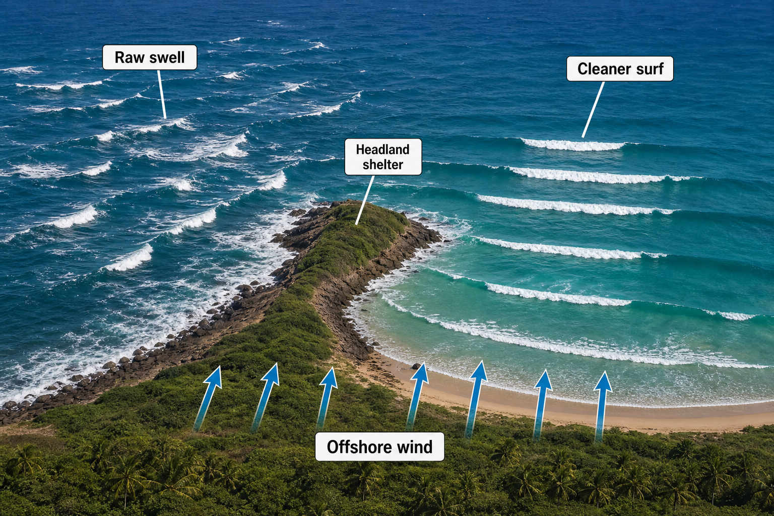
Forecast models may show a large offshore wave height, but actual surf quality depends on local wind and coastal shape. Bay of Bengal waves are often generated by weather systems close enough to simultaneously affect the coastline. That means the surf can be large but messy, especially during northeast monsoon surges or when a cyclone is nearby.
Clean conditions usually come down to a favorable local wind pattern. Morning land breezes can help. Offshore winds trailing behind a passing low can clean up residual swell. Points, headlands, and reefs can transform a raw, disorganized swell into something very surfable when open beaches are blown out. Staying tuned into real-time conditions is easier with something like a handheld VHF marine radio with weather alert capability. A handheld anemometer is also worth having to measure actual wind speed at the beach, since the difference between 10 and 20 knots of onshore wind can mean the difference between surfable and scrapped.
Step 6: Verify with Multiple Data Sources
Use global models like the European Centre model and the Global Forecast System, along with wave models based on WAVEWATCH III, but don’t rely on a single run. Compare model wind fields with satellite scatterometer data when available. Check buoy observations, coastal reports, and pressure trends from meteorological agencies.
If models project a large swell but observed winds never fully developed over the fetch, scale back your expectations. If scatterometer data shows winds stronger than modeled, the swell may overperform. In the Bay of Bengal, small changes in storm track can make a dramatic difference because coastlines and islands block many swell angles. A desktop weather alert radio can help you track changing conditions at home between forecasting sessions. A wireless weather station with barometric pressure tracking adds another layer of real-time data to work with.
Common Bay of Bengal Forecast Scenarios
Central Bay Cyclone Sending East or Southeast Swell
A cyclone forming in the central Bay and tracking northwest can send E or SE swell toward parts of India’s east coast if its wind field is aimed westward or northwestward. The first signs on a surf forecast may be a jump from short-period wind sea to 11 or 13 second energy appearing on the models. Local wind in the hours after the storm’s closest approach will ultimately determine whether that swell is actually surfable.
Southwest Monsoon Fetch Creating Consistent Medium-Period Surf
When S to SW winds blow steadily across the Bay for several days, exposed coasts can pick up consistent S or SE swell. This pattern isn’t dramatic on a pressure map, but it can be one of the most dependable sources of surf in the region. Look for a broad, sustained fetch rather than a tight compact low.
Northeast Monsoon Surge Producing Short-Period Wind Swell
A strong high-pressure push from the Asian continent can drive NE winds across the Bay, often creating fast-rising 5 to 9 second wind swell. Surf may be largest at exposed east-facing beaches, but quality only improves where the coastline bends away from the wind or where the wind drops off before the swell fades. Logging these conditions in a dedicated surf journal is a great habit for building your own forecast pattern library over time. Keeping your charts and printouts dry and readable is easier with a waterproof map case when you’re working outdoors near the water.
Forecasting Bay of Bengal waves is a balance between storm analysis and local knowledge. The basin can deliver everything from small monsoon wind swell to powerful cyclone surf, but its semi-enclosed shape makes fetch alignment, swell direction, and timing especially critical. Watch the wind field, track the pressure gradient, estimate the period, and then filter that forecast through the realities of your specific coastline. When all those pieces line up, the Bay of Bengal can turn a distant swirl on a weather map into some of the most memorable surf in the Indian Ocean.